With everyone else on the Working Holiday opting to go canoeing on the day off, I decided to take advantage of a route cut-out I had brought with me for the holiday. So before you ask, no I wasn’t being anti-social, it’s just that I don’t do water. At the time I wasn’t overly happy with a long walk option (as the walking and working of the week was catching up with me) but the only other thing on the table was to go book shopping in Hay. So with that in mind I was thinking of potential drop out points if it all got too much, but on a beautiful sunny day none were required.
....
Now the start point for the walk (as per cut out) was the Storey Arms (outdoor centre or snack bar), which in total measures 11 miles. However the walk from the basecamp along the Taff Trail to the Storey Arms came in at 1.75 miles on my GPS, so with the return from there factored in as well, this would bring the total mileage for the day to 14.5 miles.

The start from the basecamp along the Taff Trail proved steeper than anticipated, but apart from four sheep who were constantly running away from me, and a cow and a calf being herded by a warden on a quad bike, I got to the Storey Arms without incident. Thus following the instructions, I ignored the stone trail to the left of the houses that went up to Pen Y Fan, but instead took the far less distinct grass trail to the left of it. Yet despite this being more guesswork than visibly marked route I soon found myself on the somewhat flattish summit of Y Gryn.

Following a wide sweep to my right, still following an indistinct grass trail I eventually picked up the Craig Cwm Llwch ridge (passing in the process the Tommy Jones Obelisk). This was the approach to the summit of Corn Du. Oh my my was it steep or what, and despite the incredible views I was taking in, this was easily the toughest climb of the week (until later in the day). However by taking a simple one step at a time approach I eventually reached the summit.

.

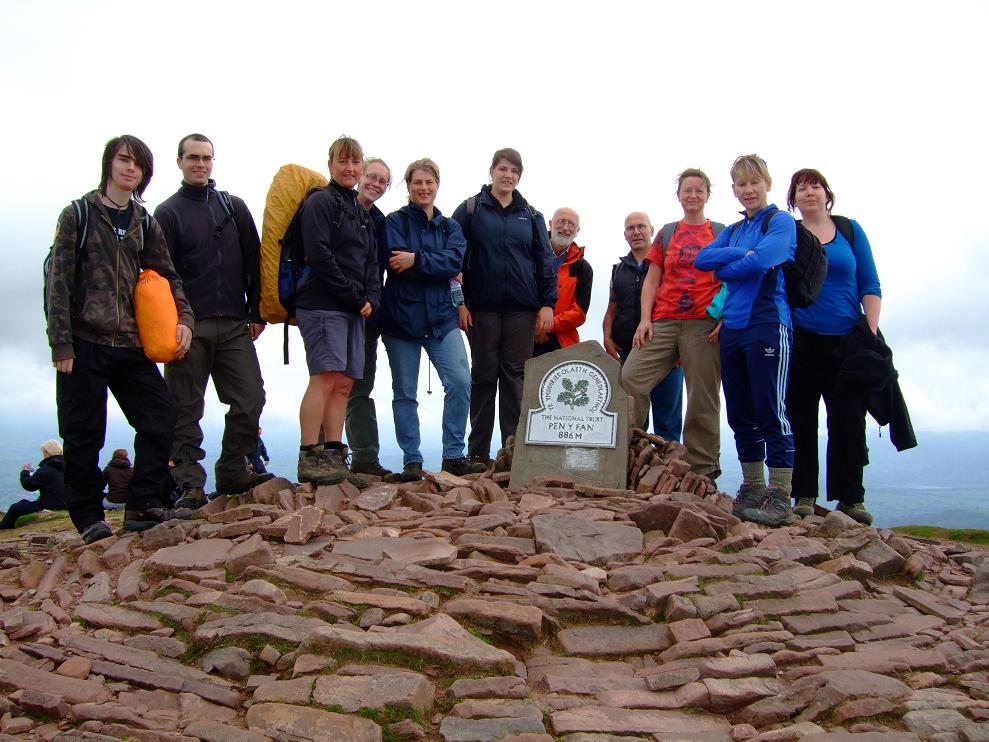
A short dip from Corn Du, and then a short climb again, found me on the summit of Pen Y Fan for the second time in a week (the other three climbs during the week, took a diversion around the edge). Anyway I found some guys up there already, so persuaded one to take my picture (see picture). After hearing one of them phone his missus, I decided that was also a good idea and checked in with the Derbyshire lady.

.

The descent from Pen Y Fan was very loose underfoot, taking me down into a valley. I took the path to the left (as instructed) to begin the climb up to Cribyn. This looked very very steep, but as the instructions suggested, it was easier than it looked (just). Once on the summit I decided to have my lunch, especially given the fact that no one else was around. A gentle but not particularly easy descent took me along Craig Cwm Cynwyn until I reached the path junction at the pass of Bwlch ar y Fan.

.

From there I continued for two kilometres on a wide and descending path towards the Neuadd reservoir complex. Along the way I met two soldier types coming the other way and passed a cyclist sorting out his bike. By this time I had been aware of another guy coming up behind me, and when I went into the reservoir complex, I met another group of four guys having a break. Thus with various gaps between us all, we climbed up by the woods at the end of the dam wall, which took it out of everyone. However the final part of this turned into a man-killing scramble, which although didn’t last long, was almost equal in difficulty to the earlier ascent of Corn Du (anyway I was fourth up out of six).

.

Once up on the ridge however, things were easy peasy, as I headed along the long ridge towards the plateau below Corn Du and Pen Y Fan. The views were incredible, and I periodically took the odd break, whilst the other guys around caught me up and passed me by (before I did the same again to them).

Once I arrived at the plateau (on my own) it was then a case of doing the descent I had been doing all week back to the National Trust car park. By now the skies had begun to darken, but thankfully the rain held off. I then continued on to the Storey Arms, passing in the other direction two of the guys from the ridge (who had since come down Pen Y Fan the other way). After a quick exchange of words, I then saw the other two of their group coming down the stone path, so I gave then a quick wave, to which they responded.
....
From there it was then along the now descending Taff Trail back to the basecamp, passing some wild ponies on the way, and of course plenty of sheep to complete a brilliant day overall. Once back in the early Eighties I ran a half marathon in the afternoon, went home for an hour, then went and did a two hour Karate class. So given the context of the week overall, this rates up there with that (not bad for a fifty year old, even if I do say so myself)
(NOTE SAME PARAGRAPH PROBLEM USING I.E. - ANY IDEAS ANYONE ?)
 The start from the basecamp along the Taff Trail proved steeper than anticipated, but apart from four sheep who were constantly running away from me, and a cow and a calf being herded by a warden on a quad bike, I got to the Storey Arms without incident. Thus following the instructions, I ignored the stone trail to the left of the houses that went up to Pen Y Fan, but instead took the far less distinct grass trail to the left of it. Yet despite this being more guesswork than visibly marked route I soon found myself on the somewhat flattish summit of Y Gryn.
 Following a wide sweep to my right, still following an indistinct grass trail I eventually picked up the Craig Cwm Llwch ridge (passing in the process the Tommy Jones Obelisk). This was the approach to the summit of Corn Du. Oh my my was it steep or what, and despite the incredible views I was taking in, this was easily the toughest climb of the week (until later in the day). However by taking a simple one step at a time approach I eventually reached the summit.
 .
.
 A short dip from Corn Du, and then a short climb again, found me on the summit of Pen Y Fan for the second time in a week (the other three climbs during the week, took a diversion around the edge). Anyway I found some guys up there already, so persuaded one to take my picture (see picture). After hearing one of them phone his missus, I decided that was also a good idea and checked in with the Derbyshire lady.
 .
.
 The descent from Pen Y Fan was very loose underfoot, taking me down into a valley. I took the path to the left (as instructed) to begin the climb up to Cribyn. This looked very very steep, but as the instructions suggested, it was easier than it looked (just). Once on the summit I decided to have my lunch, especially given the fact that no one else was around. A gentle but not particularly easy descent took me along Craig Cwm Cynwyn until I reached the path junction at the pass of Bwlch ar y Fan.
 .
.
 From there I continued for two kilometres on a wide and descending path towards the Neuadd reservoir complex. Along the way I met two soldier types coming the other way and passed a cyclist sorting out his bike. By this time I had been aware of another guy coming up behind me, and when I went into the reservoir complex, I met another group of four guys having a break. Thus with various gaps between us all, we climbed up by the woods at the end of the dam wall, which took it out of everyone. However the final part of this turned into a man-killing scramble, which although didn’t last long, was almost equal in difficulty to the earlier ascent of Corn Du (anyway I was fourth up out of six).
 .
.
 Once up on the ridge however, things were easy peasy, as I headed along the long ridge towards the plateau below Corn Du and Pen Y Fan. The views were incredible, and I periodically took the odd break, whilst the other guys around caught me up and passed me by (before I did the same again to them).
 Once I arrived at the plateau (on my own) it was then a case of doing the descent I had been doing all week back to the National Trust car park. By now the skies had begun to darken, but thankfully the rain held off. I then continued on to the Storey Arms, passing in the other direction two of the guys from the ridge (who had since come down Pen Y Fan the other way). After a quick exchange of words, I then saw the other two of their group coming down the stone path, so I gave then a quick wave, to which they responded.
....
From there it was then along the now descending Taff Trail back to the basecamp, passing some wild ponies on the way, and of course plenty of sheep to complete a brilliant day overall. Once back in the early Eighties I ran a half marathon in the afternoon, went home for an hour, then went and did a two hour Karate class. So given the context of the week overall, this rates up there with that (not bad for a fifty year old, even if I do say so myself)
(NOTE SAME PARAGRAPH PROBLEM USING I.E. - ANY IDEAS ANYONE ?)
Once I arrived at the plateau (on my own) it was then a case of doing the descent I had been doing all week back to the National Trust car park. By now the skies had begun to darken, but thankfully the rain held off. I then continued on to the Storey Arms, passing in the other direction two of the guys from the ridge (who had since come down Pen Y Fan the other way). After a quick exchange of words, I then saw the other two of their group coming down the stone path, so I gave then a quick wave, to which they responded.
....
From there it was then along the now descending Taff Trail back to the basecamp, passing some wild ponies on the way, and of course plenty of sheep to complete a brilliant day overall. Once back in the early Eighties I ran a half marathon in the afternoon, went home for an hour, then went and did a two hour Karate class. So given the context of the week overall, this rates up there with that (not bad for a fifty year old, even if I do say so myself)
(NOTE SAME PARAGRAPH PROBLEM USING I.E. - ANY IDEAS ANYONE ?)