For the second year running I hand out awards (of the purely ceremonial kind) to my favourite walks of the year, in three categories.
BEST WALK WITH IVC
Although there wasn’t any real stand out candidates in this category, my choice is one from back in sunny August (remember the Sun), which was: Chesham to Wendover – (Buckinghamshire) – 22/08/10 – 10.2 Miles – IVC
This was a scenic walk done at a good pace, with a very challenging descent to finish.
BEST WALK ON MY OWN
Staying in August again, there is a clear winner here with Chequers / Coombe Hill (Circulars) – (Buckinghamshire) – 05/08/10 – 10 Miles – Myself
This being a walk where I felt a real sense of achievement, having completed the set walk which me and Helen had initially failed to do back in June. Mind you my newly purchased GPS had rather a lot to do with that.
BEST WALK WITH HELEN
So many honourable mentions here including: My Leith Hill walk in February, our Parwich Circular adventure back in March, and our walk over The Roaches in July. In fact the more I look, pretty much every walk I have done with Helen has been memorable for one reason or another. Therefore I better not turn this into a long list of runners up, but instead I will go straight to the winner which is: Lulworth Cove (Circular) – (Dorset) – 12/07/10 – 10 Miles – Helen (Luther and Molly)
A perfect walk on our holiday’s and you should all know by now, how much I love coastal walks.
Other Highlights: Purchasing my GPS (and learning to use it of course), the potential of which I have only just scratched the surface of.
Other Lowlights: The Snow, and particularly the Ice, that has bookended 2010 and which has forced me to miss out on many walking opportunities.
Walks since last blog entry:
1 x 7 mile – Osterley Park/Grand Union.
1 x 7 mile – Grand Union/Osterley Park.
2 x 6.5 mile (run)/walks – Grand Union/Osterley Park.
1 x 7.75 mile walk – Osterley Park/Grand Union (Helen).
1 x 2 mile – Osterley Park (Frozen ice)
Tuesday, 28 December 2010
Monday, 15 November 2010
Monsal Head to Litton Mill (out and back) – (White Peak District) –(Derbyshire) – 12/11/10 – 5 Miles – Helen (Luther & Molly)
Believe it or not, Lab dogs Luther & Molly have not made any appearance on this blog (save for an inconsequential footnote) since late July. In that time however they appear to have picked up a little bit of a following, so if any of their fans are wondering whether it is worth reading on, I won’t spoil the plot too much, other than to say that on this occasion both of them nearly got drowned.
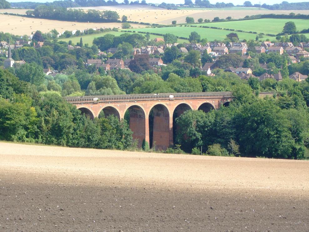
Anyway having decided it was potentially too windy to do the edge walk she was planning, Helen decided we would do something from Monsal Head. However given that Luther does not seem quite as agile these days, we decided to restrict it to around the 5 mile mark. So being ever helpful I managed to come up with one of my ‘Country Walking cut out routes’ for said vicinity, and thus we decided to go with that set one, rather than make up our own route (in the event the exact opposite, was how it actually turned out).

So starting at Monsal Head itself, and overlooking the viaduct, we descended down the stone steps until we had picked up the Monsal Trail. As we ambled along we passed on our left the former platform of the disused Monsal Railway Station. A little further on and we found ourselves looking down on our right at Cressbrook Mill, which according to Helen is being converted into luxury flats.

As there was no visible livestock around or large groups of walkers (in fact we were the only ones) both dogs were happily running around off the lead. So as we descended some stone steps our route continued by crossing a bridge over a very fast running weir cum waterfall. Thus before we knew it, bonkers Molly had already lept into the water, and was basically about 6ft away from the edge of the waterfall. Well lets put it like this, if she had gone over it, she would probably have been injured against the rocks, drowned and swept away, and neither of us could have saved her (I guess those ‘keep dogs on a lead’ signs weren’t just for the livestock’s benefit then). Anyway she was smart enough to immediately sense the danger and leapt straight back out of the water before anything happened.

So having got ourselves over that one, and crossed the weir bridge, we couldn’t help noticing that our supposed (Concession) path along the limestone walls of Millers Dale, was basically flooded (see picture). So not being all that keen on a spot of indeterminate wading in terms of both length and depth, we stood about for a bit looking at maps and scratching our heads. Meanwhile Luther, no doubt bored with this, decided to leap down onto what he thought was a pile of leaves, but was in fact an old culvert. Helen who saw this said his head disappeared under the smelly water. Now Luther is a bit of a one to panic (bit like me really) so when he found he couldn’t get out, he was both paddling and whimpering about in the water. Having ignored Helen, he just about got close enough for me to grab his collar and thus yank him out. However like most dogs, a couple of minutes later he had forgotten it had even happened.

So giving up on the suggested path for now, we ascended up the steps again, and followed the course of the river, with the intention of picking up the the route again at Litton Mill. No bad thing either, as the views were far more spectacular than anything we would have got at river level. We found a nice stony spot to have our packed lunch, all the while wondering what was going on with the vehicle in the disused/closed tunnel of the Monsal trail below.

Eventually we picked up our route again at Litton Mill approximately two and a half miles in, only to discover that Helen had left her woolly hat (whoops Fleece hat – get it right), back where we had lunch (she had been using it as a cushion). So rather than abandon it, we decided to leave the official route, which we had been diverted off anyway, for another day. This was now going to be a straight out and back mission to retrieve said hat. Again no bad thing in my book, as all routes look different to me in the opposite direction, and the scenery was no less spectacular coming the other way. Fortunately the one couple we met coming towards us, having had the same problem with the river, had left said hat alone and we were soon able to retrieve it.

Picking up the Monsal Trail again, Helen decided to slightly change the finish, as she doesn’t like straight out and backs, and thus we finished by crossing over Monsal Viaduct itself. A good time to finish too, as the rain was starting to come down, with the light getting ever more gloomy. However with GPS in hand, I did have to reach the car by a circular route of the expensive car park, in order to get the distance up to an official 5 miles.

Walks since last blog entry:
1 x 9.25 mile (9 kg ruckack walk) – Putney to Osterley.
1 x 15.5 mile (9 kg ruckack walk) – Richmond Stn/Park (outer/inner loops).
1 x 6.5 mile (run)/walk – Grand Union/Osterley Park.
1 x 6.5 mile walk –Osterley Park/Grand Union.
Sunday, 17 October 2010
Putney to Syon Lane – (Surrey/Middlesex) – 17/10/10 – 9.25 Miles – IVC + Helen

Well not to put too fine a point on it, but this has been one of the toughest months I have ever had to live through. The stressful upshot of which being, that my health and energy levels have been completely on the floor for about three weeks now. So if ever I could have done without having to lead a walk for IVC this was it. Or to put it another way I didn’t want to be out on anyone elses walk let alone leading one of my own. However a commitment is a commitment, and so I was of course prepared to lead my walk in the Vale of Aylesbury around Coombe Hill and Chequers.
Yet if my stress levels weren’t high enough as it was, I got a call from a senior IVC member on Thursday afternoon, pointing out that there was a replacement bus service running on both the Chiltern and Metropolitan lines over the weekend. Thus my intended walk was immediately going to be a travel logistical nightmare, and so I had to make a quick decision to dump it, and improvise a new one. Thus I am grateful to two IVC members, one for pointing out the travel minefield I was about to step into, and the other for getting the new updated walk published over the old one at such short notice. That said there was always the constant worry that someone would still turn up on the old walk and I would be getting a very angry phone call. Thankfully that didn’t happen, however maybe even now there is still someone waiting at Wendover Station ………….. ?
Anyway this walk is my bog standard Putney to Syon Lane one which in normal circumstances now only merits a footnote on this blog. To my surprise however it was more of a novelty to other people and thus we had some 15 people including myself turn up for it. I was also grateful for Helen’s presence lest I take some sort of health dip on the walk itself, whereby she could take over (being that she has done this one before). So after a little confusion where we all waited outside Putney Exchange shopping centre for some imaginary person to visit the toilet, we were able to pick up the towpath and be on our way.
The Thames towpath at the Putney to Barnes end of things is fairly congested (especially for a sunny Autumn Sunday like this) with joggers, cyclists, dog walkers, and the rowing fraternity manouvering their craft. Anyway we plodded on through them all passing the usual landmarks like Fulham football club, Harrods furniture depository, Hammersmith Bridge and eventually Barnes Bridge.
With no set pub decided for lunch, once we reached Barnes I decided to pick the first one we came to, which was the Bulls Head. This turned out to be a Jazz themed pub, with an actual gig in progress in the music room. Food wise it was a tad disappointing that the roast chicken, and bangers and mash, that were both chalked up on the board were not available. Nevertheless most people had a roast of some sort, and I had bangers and bread plus the obligatory pint of cider. As we regrouped outside, two of our walkers decided that was as far as they wanted to go on this occasion, and dropped out there.
Onwards we went, with me pointing out where the Boat Race finishes at Chiswick Bridge, and having eventually reached Kew Bridge we crossed over there to the Middlesex side of the river. Now I had a constant nag all day, namely that there was only one train per hour from Syon Lane back to Waterloo. Thus I didn’t want to lead the group into the station with them having something like a 45 minute wait for a train. So with other people keen for a tea stop anyway, this seemed a good way to make the timings work. Thus on our way in and out of the Towpath, we spotted a Premier Inn in Brentford which turned out to be a perfect spot for some afternoon tea in their garden.
Unfortunately with the guy serving having to go and find more milk for the very popular hot chocolate, the time it takes people to drink these things, and then the inevitable last minute visit to the toilets by the male members of the group, we ended up spending 40 minutes there. That was 10 minutes more than I bargained for and which put us under some serious time pressure. Well I think you know where this is going. Thus back out on the Thames Lock / Grand Union Canal section no one seemed to be showing the slightest urgency to speed things up, despite my best efforts to get everyone moving along. Thus by the time the quickest of the group, reached the entrance to Syon Lane station, they were just in time to see the hourly train pull out. Needless to say everyone then looked at me with a ‘now what are we going to do’ look on their faces. Fortunately I was quickly able to get them on a bus round the corner, to Osterley underground station, whilst hoping no one would make a point of saying, “but you told us to buy an overground return to Syon Lane”.
Anyway whatever, considering the bigger picture things didn’t turn out too bad overall. In retrospect if I had time to think the walk through on Thursday evening, I would have said for people to buy a single to Putney, with us continuing on the Grand Union Canal all the way to Boston Manor underground. Anyway if there is a next time……… (incidentally I forgot my camera, so the picture here as taken on a previous walk, is a representation of what we saw on todays walk).
Walks since last blog entry:
1 x 6.5 mile (run)/walk – Grand Union/Osterley Park
2 x 6.5 mile walk – Grand Union/Osterley Park
1 x 3.75 mile Hellbank (circular) – via Beeley Village – Helen (Luther & Molly)
Monday, 20 September 2010
Crowhurst to Battle – (East Sussex) – 19/09/10 – 11.7 Miles – IVC
This walk was a little bit further out than I was anticipating or particularly wanted to travel on this occasion. So perhaps if I had read the details a little more closely I would have noticed it was an hour and a half out from Charing Cross. Anyway whatever, nine of us including our fusspot leader assembled at Crowhurst station, for a fine day that had just a slight Autumn chill.
Our first point of interest was a disused railway bridge, where we made our way under it through an aluminium tunnel sitting on top of the sleepers. Having negotiated that our fusspot leader was keen to point out that the silvery/white bit at the bottom of the horizon was in fact the Sea. A bit further on and we were made to turn round again to check out the faint outline in the far far distance that apparently was Beachy Head.

Having crossed a main road we found ourselves walking through a heavily wooded area under a lot of canopy. We made way for two little girls riding junior size ponies, and then soon after found ourselves being followed by a black bull terrier of sorts. This dog was a bit of pest partly because he was constantly under our feet, and partly because he thought it was a great laugh to run slightly in front of our group, and then squat down and defacate in our path. Having done this on three occasions, he then returned to his teenage girl owner (who had no doubt put him up to it).
Our fusspot leader had been chuntering on about the upcoming golf course, and once we got there kept going on about the muddly path through and around it, whilst the rest of us were debating did he mean muddy or muddly ? Whatever he meant, he was basically taking this walk out of ‘Time Out Country Walk’s book one’, whilst our leader of all leaders was giving his version of where we should going instead using his OS map. Anyway having negotiated that, our fusspot leader started a new panic saying we had to get to the pub by two thirty, otherwise there would be no lunch (something that had apparently happened on the previous week’s walk). When we did finally get there at two twenty five, the pub turned out to have a new name and owners, and was serving food all the way up till nine o clock.
Anyway this was a great little pub (sorry I forgot the name, but it is in Crowhurst for those who need an exact reference) run by a cheery landlady and her husband. I had a burger, two eggs and chips, plus a pint of cider, all for eight quid (rare value in a pub these days). Yet once on our way again, another member of our group proceeded to lecture me to tears about why I should do more cooking for myself, until I had to pretend to faint in order to get him to stop.

Having seen the 1066 footpath signs I did wonder whether we would be seeing something a little historic, but apparently not as we were going to be approaching Battle from the wrong side. Oh and apologies for the lack of decent pictures by the way, but having assured me the night before that he was fully charged up, my camera decided at around this time to conk out.

As we passed through another pine mono culture, there was more debate between fusspot leader, and leader of all leaders over which way we should be going. This got a little more regular after fusspot leader, who had been threatening us all day with this gauntlet of nettles we were all going to have to negotiate later on, was overruled by the leader of all leaders who found us a sting free passage instead (much to my disconsolation actually, having found a large catapault type stick to swat them aside).
Having negotiated a different gauntlet of sorts, namely a sewage works, things inevitably came to a climax when the group split in two. Fusspot leader wanted to stay to his exact route, which would include taking in Battle Abbey. However the leader of all leaders, rightly in my view giving the gloom of the day and how time was moving on, wanted to get to the station in order to get the 1820 train. Thus five of us went with him, whilst fusspot leader found himself now leading a group of two who certainly missed that train, with the next one going at 1843. Obviously one felt a tad ungrateful to our fusspot leader here (although end of walk breakaways are the norm for this group) however I didn’t get home till 2100 hours, and that was really enough for one day.
Walks since last blog entry:
1 x 6.5 mile (run)/walk – Grand Union/Osterley Park
1 x 14 mile (9 kg ruckack walk) – Richmond Stn/Park (inner & outer loops).
Monday, 30 August 2010
Farningham Road to Otford – (Kent) – 30/08/10 – 9.75 Miles – IVC
I really must get out of the habit of frequenting these chain cafes in mainline stations (albeit one usually does so in order to kill a bit of time). Anyway the small cup of hot chocolate and chocolate twist I had at Victoria Station was equivalent to ‘death by sugar’ as well as costing me nearly a fiver.

Anyway starting at Farningham Road station our nine man group, set off on this bank holiday Monday along the scenic Darenth Valley Path, following it upstream pretty much for the majority of the morning and afternoon. The day started a little bit chilly but the Sun eventually put in an appearance which meant I was soon able to take my rainjacket off. Initially we were just folllowing the river, but this soon expanded out into the valley itself.

Anyway starting at Farningham Road station our nine man group, set off on this bank holiday Monday along the scenic Darenth Valley Path, following it upstream pretty much for the majority of the morning and afternoon. The day started a little bit chilly but the Sun eventually put in an appearance which meant I was soon able to take my rainjacket off. Initially we were just folllowing the river, but this soon expanded out into the valley itself.

.

Lunch was Eynsford where we had to cross over the footpath free bridge by the fjord, along with a large queue of motor cars, in order to reach the pub. Thus expanding my culinary repertoire I decided to try the fish and chips, and also had a Magners cider (much better than the gassy Strongbow). Anyway none of us had a pudding and we were soon back on the Darenth Valey Path again.
Now there was a Roman Villa in these parts that was being vaguely promised to me, as a stop off point. However that was in the grounds of the uninspiring Lullingstone Castle (hence no picture) so we didn’t get to see that. Instead after following the Darenth river we ended up, in a local tearoom where we were faced with an enormous queue, and a garden full of uncleared tables. I decided to have a Magnum Ice Cream (probably because I thought there was some sort of link with my earlier cider), and cleverly passed it back down the queue when I got near the till, for it to be replaced with another less melted one.
As we approached Shoreham station the group split into those who wanted to end there (which three of the group did), and those of us who were carrying on to Otford. In the course of which we passed by a golf course and cricket ground that we all had been past before on another walk. Anyway we eventually got to Otford station in time to watch the half hourly train pull out. Thus the next half hour was spent in a shelter debating the fate of a bee on the ground that had two cigarette butts beside it.
So overall a very scenic walk, in a nice Autumn temperature (I was comfortable in a t-shirt). In normal circumstances I might have grumbled that the pace was a tad too leisurely, however due to the severity of the run/walk I had done the previous day, that was probably all my legs could cope with.
Walks since last blog entry:
1 x 6.5 mile (run)/walk – Grand Union/Osterley Park
Sunday, 22 August 2010
Chesham to Wendover – (Buckinghamshire) – 22/08/10 – 10.2 Miles – IVC

After the previous day’s National Trust gentle jaunt, it was back to some serious walking for this wander through the North of the Chilterns. Now most of us were confused in some way or other by the travel instructions, from Marylebone to Chesham. Not least me who for the third time now have paid the return train fare on this line, when my Oyster would have taken me all the way to Chesham. Thus I only really needed a single ticket back from Wendover to Amersham. Hopefully by the time I get to lead my Chequers walk, I will get it right and save some money. Another member getting it wrong was the guy who pulled his car up outside Chalfont & Latimer for the irregular branch line to Chesham, only to see us pull out and thus requiring him to come and chase us in his car.

All this served to wind up our leader who was fretting about missing the hourly train home, before the walk had even started, and which was to become a theme throughout. Thus given that he is one of the fastest walkers in IVC, this served only to encourage him to really push the pace, and for quite a few stretches I was the only one (when I had a mind to) who could catch him up and stay with him. That said I found it refreshing to be walking at a decent pace, and according to my (pinch of salt) GPS, when we were moving (as opposed to waiting for everyone to catch up) we averaged 3.5mph throughout the walk.

At one point whilst comparing general GPS readings with our (much slower) leader of all leaders, I popped mine back in my rucksack side pocket and walked on. By some miracle I decided I would get it out again to give it a second check, only to discover I had missed the pocket and thrown it some way back on the ground (thankfully its bright yellow casing called out to me to in the Sun to come and rescue it). Thus by this time the Sun had come out to give a much brighter day than Saturday, and one that was slightly less humid as well. Our nine strong group also found itself being joined at different points by two small dogs and further on by two larger ponies.

Lunch was at the Cock and Rabbit which seemed part pub and part Italian bistro. Thus the Don Corleone figure who took our orders at the bar left one in no doubt about the authenticity of the establishment, or the potential consequences if you didn’t pay your bill. The rather impressive young waitress also had an Italian name, so we are definately talking family here (if you know what I mean). Anyway given that my flat is full of ready meals coming near their sell by date (plus the fact that I had fish & chips in the pub yesterday, thus limiting my choices) I chose to slurp away on the vegetable soup and garlic bread (+ pint of Strongbow).
Post lunch and our leader went straight back into his fretting about the train mode. All of this was quite amusing given that on the one hand he felt we had to be at Wendover station for five o clock, but on the other hand didn’t actually know when the train actually left. Even more amusing was that soon afterwards he had taken us all on a wrong turn, confirmed by yours truly’s GPS (not that I was given any thanks for this assistance). Thus our leader then officially announced with some exasperation that we now had no chance of making the five o clock (?) train, an opinion he was continually to revise throughout the rest of the afternoon.

.

After walking through a number of beautiful sunbaked Weetabox fields, we eventually picked up the Ridgeway (parts of which I covered on the Coombe Hill/Chequers excursion). Running alongside it was basically a sheer drop into a valley below. The only problem being that our leader required us all to descend straight down it (paths not included). This however was too much for four of our group, who led by the slower leader of all leaders, decided they were taking a different route at this point. Wisely, given age and ability considerations, they decided risking missing the train, was better than risking breaking their necks. Anyway five of us did it, although it was certainly precarious not least for the bracken and wood one had to trip ones way through (believe me the picture does not do this descent justice). No sooner had we reached the bottom of this valley however, we were then required to make an immediate ascent back up the lions share of Boddington Hill. Yet even then the endurance test wasn’t over, as yet again we were required to make the steepest of descents again. This time yes, it was on a smooth wide path, however such was the drop you could barely stop yourself from breaking into a run down it.

.

Once all that aerobic activity had come to a finish we walked through the virtually closed town of Wendover, arriving at the station at 1645, leaving us plenty of time for the 1713 train to Marylebone. Thus according to my (pinch of salt) GPS, we had covered 10.2 miles which our leader seemed in broad agreement with. There was some worry whether the other four who had taken a different route would make the train, but despite adding another mile, they were all present and correct on the platform by 1705.
Saturday, 21 August 2010
Knole House (out and back) – (Kent) – 21/08/10 – 4.5 Miles – IVC

A recent IVC Summer walking innovation, is to have an additional shorter walk on a Saturday, combined with a visit to a National Trust property. As this was the first Saturday I have had free since …….. (oh I dunno, the Normal invasion probably) then here was an opportunity to support this new idea. Thus today’s event was slated to be a six mile walk combined with a visit to Knole House in Kent.
Starting at Sevenoaks station our twelve strong group soon found its way into the property’s Deer Park, which apparently in its entirety is 1000 acres (although the Trust only owns 43 acres worth). After a mile and a half we reached the driveway to the house where a small breakaway group went straight in, with the rest of us continuing our walk in the grounds of Knole Park estate. All around us there were plenty of young deer to be seen, as well as a number of golfers. So much so in fact that there were warning signs regarding the golfers. Thus in a brilliant flash of wit, I pointed out to everyone that the signs were there as it obviously must be the putting season.
As we headed off in the direction of the pub, the sky looked very overcast and threatening, yet this was one of the most humid days I can ever remember (or either I have some sort of fever) as I was sweating buckets. Lunch was at the Bucks Head where three of us had the last of the fish and chips, plus I had a pint of strongbow. After retracing our steps back to the house, those of us with National Trust membership or visitor cards got in for nothing, whilst the rest of the party had to pay £10.50 each.
Knole House has been in the residence of the Sackville family since 1566, although the heart of the building was built substantially earlier between 1456 and 1486. Now a lot of what one sees here, tends to be familiar to a lot of National Trust properties. Although I did particularly enjoy the erotic carving at the foot of the stairs of a lady reclining on a couch, the portrait of James 1st (when a steward pointed out to me how his eyes and left foot follow you around), and also had my interest piqued by the fact that this was where The Beatles made the videos (or whatever they were called then) for both Strawberry Fields and Penny Lane. Also I have just now looked on Wikipedia where the it says the property is known as a calendar house because it is reputed to have 365 rooms, 52 staircases, 12 entrances and 7 courtyards. Needless to say nothing like that is on view to the public, as the Sackville-Wests still own half the house, all of the gardens, and the majority of the estate.
So after buying an eco stapler in the gift shop I reassembled with everyone else in the tea rooms, where I had a mug of coffee and a slice of coffee cake (well I like coffee !). The plan at this stage was to follow the same route home, however a shorter more direct route was devised of about a mile and a half, through the main entrance and back into Sevenoaks. So overall an interesting and relaxing day.
Walks since last blog entry: 1 x 9.25 mile (9 kg ruckack walk) – Putney to Osterley.
Thursday, 5 August 2010
Chequers / Coombe Hill (Circulars) – (Buckinghamshire) – 05/08/10 – 10 Miles – Myself
An unexpected day off from work gave me a chance to make another attempt at the Chequers walk, which me and Helen ultimately gave up on back in June. My reasoning being that one head + GPS, is better than two heads and no GPS. Also I had vaguely promised on Sunday that I would lead a walk for IVC in September, with this looking the most likely candidate. So talking of the GPS, it was a pleasant surprise to see that the grid reference on the ‘route cut out from Country Walking (May 2010 issue) exactly corresponded with what the GPS was telling me (not sure why I expected it to be different – but anyway).

Obviously the first four and a bit miles of this one was not expected to present me with any problems, being that we had done it both ways last time out. The only difference this time was that I had spotted a potential early lunch stop for IVC the previous evening whilst studying the small map. Thus in no time I had reached the Boer War Monument on the top of Coombe Hill, which admittedly is only at the 1.5 mile point (or is it, as the GPS only showed 1.38 miles – more on that later). Also and thankfully the wild ponies were nowhere to be seen.

Now the pub lunch stop, involves leaving Coombe Hill (Monument), in the complete opposite direction to the route, and thus descend down to Butlers Cross. Oh my my though, what a steep and precarious descent. Yet when I finally got down to the road, the golfers crossing there pointed out that there wasn’t any footpath, and that I would have to walk on the road itself. However after about half a mile, I arrived at The Russell Arms, where I had a pint of cider, and two eggs, ham and chips. Everything was as it should be there, which was just as well considering at 12.30 I was their only customer. What goes down must come up though (relax I am not talking about lunch), and the ascent back up Coombe Hill (now the second ascent of this) was in a league of its own, and bore no relation to the gentle climb from the station. I like to attack a climb but this one had me stopping and panting hard every 20 yards. Eventually I made it back to the Monument where I temporarily collapsed in a heap to get my breath back. Methinks I better make this clear with IVC, and suggest the majority bring sandwiches.

Continuing on from the Monument this time I took the correct path (to last time out) all the while admiring the stunning views over the Vale of Aylesbury, then continued through the beech wood, before eventually and correctly doing a right turn (again unlike last time) out onto the road. There I picked up the Ridgeway/South Bucks Way through the wood before eventually leaving there and crossing the road that takes you into the grounds of Chequers estate. No idea whether Cameron was in residence, but there was a small number of workers with strimmers cutting green stuff (although in all likelihood they were probably Mi5 operatives carrying disguised machine guns). Not wishing to risk the wrath of anyone, I stayed on the correct path, eventually walking past the wood on my left, and railway sleepers to my immediate, and chequers to my far, right (if you check out the photo you can spot Coombe Monument in the distance).

So finally I had arrived at the bit that had caused us so much grief last time out. Having taken an immediate grid reference reading, it was apparent that not only was I not as far along as we thought we were at that time, but I still wasn’t as far along as we thought, when we assumed we had sussed it all out in the aftermath. Nevertheless this is still a confusing section, and I did resort to the inbuilt compass in the GPS here, to make sure I was heading in a general Northerly direction. The other big mistake we made back then was thinking that Great Kimble on our left was actually Beacon Hill. In fact we never got as far along on the last trip to see Beacon Hill, which was ultimately further along and on our right. The correct thing to do was to cross the road that I had traversed down to Chequers before (along with any number of other dead ends we had taken). Helen did suggest this, along with other suggestions as well, but at that time I was becoming overstressed and cooked by the heat and it was just one suggestion to many. So near and yet so far.

.

Today of course is a different day, and with the GPS to keep me on track I sailed past Beacon Hill on my right, with more stunning views over on my left. Eventually I reached the road, and took an immediate right down the lane opposite the church at Ellesborough. Cutting across a vast field of straw I could once again spotted the Coombe Monument way up in the distance. Once out onto the road it was past the golf club and left onto the bridleway to make ascent number three of Coombe Hill. Well this one was every bit as bad as the the second one from the pub at Butlers Cross (I can’t wait to see this string out a walking group), but eventually it levelled out and dissected the path from the Monument at the kissing gate, that I had come through earlier.

Carrying straight on I crossed a car park into Low Scrubs, with the ‘route cut out’ stating that the path is hard to follow. Well that would be because there are three paths, and naturally I took the wrong one. After 5 minutes I began to suspect this, and one grid reading soon confirmed it. It was then a case of retracing my steps and correctly picking the right path from the two remaining. Eventually I picked up a bridleway that went on for a good mile, firstly on a long descent and then taking a sharp left where I had to make way for both a mountain biker and then a girl on a horse. After crossing another green and glorious field, I found myself coming out onto the road bridge just outside Wendover station and thus ending the walk. So overall I was mighty pleased with my efforts as well as the walk which in its entirety is definitely one to do over and over again (what a shame me and Helen didn’t get to complete it back in June). That said the GPS was a vital tool today without which I would have still struggled at the point we did last time, and would most definitely have had problems at Low Scrubs.

However speaking of which, I was most perturbed when I got to the station to see the read out saying that I had only walked 8.89 miles. Well that can’t be right methinks, as it says 9 miles on the ‘route cut out’ and I had to have added at least a mile to that on the diversion and back to Butlers Cross for lunch. My guess therefore is that the GPS satellites measure distance in straight flat lines, and thus make no allowance for ascents (for instance a mile ascent up, may only be 400 metres covered in a straight line). Thus given that there were three ascents here, two of which being exceptionally severe, then that must be where my missing mile went. Anyway I will ask around on that one.
.
.
Walks since last blog entry:
1 x 6.5 mile (run)/walk – Grand Union/Osterley Park
Sunday, 1 August 2010
Riddlesdown to Coulsdon South – (Croydon) – 01/08/10 – 8 Miles – IVC

My first walk with IVC for a couple of months and (even more important) my first chance to test out my new GPS (The Garmin E Trex H, for those of you who need a product reference). Therefore I think it is only fitting that I deal with that first. Thus the day started well as I was able to see the average speed of the train I was travelling on, how long it was waiting at the station, and how far it travelled between stops. Then once on the walk itself I was able to compare/check the map grid location with our walk leader’s OS map (everything working as it should there then), as well as compare general GPS owners chit chat with our leader of all leaders, who happens to have the exact same model. There was one annoying member of our group who felt he should be the centre of attention, merely because he had just completed a 100km walk along the South Downs in under 30 hours, however I did my best to drown him out with regular updates to everyone over how far we had just come. In fact everything was going swimmingly up until lunch, and then the batteries ran out …………. Oh dear, it looks like my old rechargeables that have hung about the flat for ever, may not be up to the job, and that I might have to invest in some real ones. So swiftly moving on…….

This walk was loosely based on a couple of stages of the London Loop, despite our leader’s reluctance to admit that (the signs however were a bit of a give away). Thus our first point of interest was RAF Kenley (circa 1940’s) situated on Kenley Common. Well actually I am inaccurately stating that, as these days it is used merely as an aerodrome for gliders (but watch the film The Battle of Britain, for a true reference point). Thus having left there in the course of which we were overtaken by a lady on her mobility scooter (+dog), we eventually made our way into Coulsdon Common, before ultimately arriving at our lunch stop at The Fox pub in Old Coulsdon.
Having arrived at the pub we were surprised to see one of the regular members already there tucking into his main course. It turned out he had missed the train, but by a combination of buses and cycle routes had made his way there via a different route to us. Now this was a really nice pub where the food was reasonably priced (for example £7.95 for a roast dinner), the service was quick and friendly, with the pretty young waitresse’s circling round us diners with an elaborate tray of sauces and mustards . For my purposes I had the open Chicken and Ham pie, with Fries and Peas, as well as the compulsory pint of Fosters. All very nice too, in fact so much so that I decided it was urgent that I had a desert to go with it. Now unlike the usual six quid a throw which seems to be most pub deserts these days, the Profiteroles (with fresh cream and chocolate fudge sauce) were a far more reasonably priced £3.95. Oh my god though you had to see the size of them to believe it, as in effect what I was served was to all extents and purpose two helpings. So as yummy as they both were, they actually beat me, and I was reduced to hiding the last couple of mouthfuls under my spoon.

The second half of the walk took us through the chalk ridges and dry valleys which form the dip slope to the North Downs. Undeterred with the fact that my GPS was now only able to stay on for a couple of seconds at a time, I tried to convince anyone who would listen (and there weren’t many takers at this point) that we had really only travelled 4.82 miles by the time we reached Coulsdon South station. Fortunately (lest anyone might have felt short changed) our leader of all leaders was able to pull out his fully powered one, and confirm that we had actually travelled 8.1 miles. Anyway the battery issue is merely a teething problem, with my new GPS looking as if it does everything I want it to do, and it will prove a good investment.

NOTE: The new photo size is an experiment for this post, based on the fact that most people probably don't click on the pictures themselves for a larger version. Anyway if it doesn't look right on this post I will return to the old format.
Tuesday, 27 July 2010
The Roaches – (Staffordshire) – 24/07/10 – 8.5 Miles – Helen (Luther and Molly)
This walk was a little bit further out then we normally venture, but given how Helen had never been to the Roaches (me neither), it was well worth the hour’s drive. Our template for this one being ‘route cut out No 12’ from the Spring 2008 issue of Country Walking.
Naturally enough for us we started off on the wrong path, heading up towards the very exclusive looking Roaches Hotel. We weren’t unduly concerned however as we knew we were coming round the back of Hen Cloud. In fact we were even able to pick out Jodrell Bank (or someones overachieving Sky dish) in the distance. However by the time we came round the side of Hen Cloud, facing towards the Roaches, we went into usual confusion mode, deciding not to visit the top but instead make a straight line for the Roaches themselves. This involved smashing and stumbling our way through a field of heather, all the whilst disturbing the feathered wildlife in the process. Not our finest moment, especially after later reading a notice on the gate requesting that you don’t do things like that. Anyway as if to have its revenge, a tangle of bramble wrapped itself around my leg and ripped it up as best it could.
Naturally enough for us we started off on the wrong path, heading up towards the very exclusive looking Roaches Hotel. We weren’t unduly concerned however as we knew we were coming round the back of Hen Cloud. In fact we were even able to pick out Jodrell Bank (or someones overachieving Sky dish) in the distance. However by the time we came round the side of Hen Cloud, facing towards the Roaches, we went into usual confusion mode, deciding not to visit the top but instead make a straight line for the Roaches themselves. This involved smashing and stumbling our way through a field of heather, all the whilst disturbing the feathered wildlife in the process. Not our finest moment, especially after later reading a notice on the gate requesting that you don’t do things like that. Anyway as if to have its revenge, a tangle of bramble wrapped itself around my leg and ripped it up as best it could.

So finally we began our climb onto the roaches, with a large group of lunching walkers who were sitting on the first part of the rocks staring down at us, and suggesting that we weren’t going to have the place to ourselves. However the Roaches is really a haven for the rock climbing fraternity, and there were plenty of them up there, clanking away with all their metal hooks attached. We decided we were going to have lunch as soon as we were near the summit (giving us an excellent view), whilst Molly and a dog belonging to some nearby climbers (also eating) tried to work out their differences as only dogs can. Luther for his part seemed fairly non-plussed.

Moving off again we made our way to the top and followed the path along, being passed by one guy who Helen described as being ‘dressed like he was on the way to the office’. The weather was closing in a bit at this point which meant for the second time in two days, Helen hogging my £8 National Trust umbrella. Not that I minded as having made our way past the trig point and then down from the Roaches on a perfectly laid out path, she bought me an ice cream (which in truth had been promised 24 hours back), from the cleverly parked van at the bottom.

We then crossed through the stile and headed off, initially taking the path to Danesbridge, before taking a right turn at a fingerpost pointing to Gradbach. In the process of which Luther managed to spook a Japanese girl sitting on the edge of a precipice having her photo taken, and in conjunction with Molly charm another little girl who was leading a party of adults coming in the opposite direction. What was slightly disturbing was in the process of this section of the walk, we came across two dead sheep, as well as assorted lumps of wool scattered about. We didn’t dwell on that too long however, and instead found our way to the entrance of Luds Church. Now ‘Lud's Church (sometimes written as Ludchurch) is a deep chasm penetrating the Millstone Grit bedrock created by a massive landslip on the hillside above Gradbach’ (well rather I meant to say all that, but instead just copied and pasted it from Wikipedia). Anyway the four of us ventured down and along it, wondering why we couldn’t find any altars or crosses. There was also a slight sea air smell within the chasm.

.

Retracing our steps out of it, we began a long and gradual climb, all the while looking out for a stream that we needed to cross. When we eventually saw the stile and ice cream van we came through earlier, we decided to stop and finish off what was left of our sandwiches (well in my case a sausage roll). There Luther and Molly proceeded to show us up, by a disgraceful piece of bullying of a smaller dog coming the other way. However in best Helen tradition, she pointed out to its owners that it was really their fault, because their dog was on a lead.

So after resisting the request to buy me another ice cream from the van, Helen, myself, and dogs in disgrace, climbed back up to the top of the Roaches. In this case it literally was the top, as we discovered we had passed the path we had taken up from the lower level earlier, and had to retrace our steps to find it. All the while along here I found myself being victimised by some sort of wasp making circles around me, which Helen incorrectly pointed out was all in my imagination. This return part of the walk along the Roaches went very quickly and we soon found ourselves heading down from there and facing Hen Cloud. The route cut out suggests you extend the walk by heading up to the top of it, but having been round the side of it already, we passed on that one. However having come to the bottom, we couldn’t decide should we do a right at the gate, or go through that and take a right at the next gate. I was overruled on this one, but although we found a path down to the layby, the gate there to get out onto the road was locked (guess my choice was the right one after all). Anyway I somersalted over the gate, whilst Helen and dogs took a diversion through some nettles to come out further along. Thus having made our way back to the car, Luther for his part was near out on his feet and had to be assisted with his leap into the back. Poor old boy, no such tiredness however, with me, Helen and Molly (right !).


Monday, 26 July 2010
Matlock (Circular) – (Derbyshire) – 23/07/10 – 5.5 Miles – Helen (Luther and Molly)

Having parked at Matlock Bridge and started climbing up a steep gradient to pick up the Limestone Way, we were met by a bare chested man (+ partner) coming towards us, who claimed to be carrying his red shirt so as not to provoke a nearbye bull. In the event the bull had clearly come from his own mouth, as the livestock in the nearby vicinity were of the docile cow variety. That said with young calves around, I for one was prepared to disown Luther and Molly if there were any problems.

Anyway onwards and upwards we went, and what do you know it started to ever so slightly drizzle. Being the gallant chap I am however I did not hesitate to lend Helen my £8 National Trust umbrella, but only because (unlike Dorset) I happened to have my waterproofs with me.

.

In due course we found our way into the village of Bonsall, where we enjoyed looking at a replica carving of “T” Owd Man, as well as letting the dogs drink from one of wells being prepared for the following week’s Well Dressing (all the while supervised by a young boy and his Mother). However having gone through the village Helen’s route planning went a little askew as we first climbed up and then climbed down, as well as going to the gates of a churchyard and turning back from it again. The running order was soon restored however as we skirted round a quarry, as well as skirted round some more cows just prior, before eventually making our way up to the Heights of Abraham. There we partially saw the cable cars that serve Matlock Bath as well as Riber Castle in the distance. None of this information being brought to us by an idiotic talking telescope that shut up after a couple of minutes, and which neither of us could properly see through (there are better ways to spend 50p). From there we made our way through Masson Leas Farm, picking up the Limestone way again before eventually retracing our steps back to Matlock

What I found strange about this walk (which was a Helen creation) was that from the off we seemed constantly to be going upwards, but it seemed to end with the shortest of descents back to the car. Anyway Helen later used the scientific OS map and a bit of string method, to determine that we had done 5 ½ miles, and you can’t get more precise than that.
Tuesday, 20 July 2010
Langton Matravers (Circular) – (Dorset) – 16/07/10 – 5.75 Miles – Helen (Luther and Molly)
The last day of our week long Dorset caper and we decided it was time for a bit more of the coast. Again we took our guidance from one of the Country Walking ‘route cut outs’ (December 2008), which again was backed up with OL15.

Well this was a windy day to start with (check out Helen’s new hairstyle). In fact sitting in the car at the start I was more than a little concerned to see other couples setting off in full rainjacket/fleece mode, whilst I was protected by no more than two t-shirts. Nevertheless despite the gales, they proved more than
adequate once one got going.

So after a tractor driver had taken mercy on us by deciding not to mow us and the dogs down on a narrow lane, a few twists and turns later we were heading down to the edge of the cliff to look over at Dancing Ledge. The wind was still giving it some at this point, but fortunately blowing us away from the edge and a watery oblivion. We thus continued on the coastal path, stopping briefly for Helen to have one of her cliff top snoozes. Once again the doggies were in their element going back and forth, with Molly covering three times the distance we were doing, and Luther covering double.

Eventually we turned inland by the disused quarries at Winspit (which lies between the hills of East Man and West Man) and which Wikipedia reveals was used in WWII for both naval and air defences, as well as being used more recently as a TV film set for Blakes Seven and Doctor Who. One flight of stairs, and a couple of fields later, we found ourselves on a long driveway heading up to the small village of Worth Matravers (not before the canine drinking facilities left outside by one thoughtful householder was taken advantage of). Oh and by this time the wind had now become the faintest of memories.

Once in the village however, Helen tried to start her now usual game of “we didn’t come along the right path” confusion (which to be fair is often correct), but got short shrift from me this time, especially when the duck pond landmark was exactly where it was meant to be. So having stopped there for a few minutes we did as recommended and made our way to the Square and Compass (passing the stone egg – as pictured), where we enjoyed half a cider each, and half a pasty each. Helen in this instance did the honours reporting back that there was a mind boggling choice of ciders drink wise, and exactly one type of pasty food wise, to choose from. In the event both were scrumptious, but the real reason to visit this pub is the beer garden, which has to be seen to be believed. My best attempt at a description being that it is furnished in wood and stone in the best traditions of the ‘Mad Hatters Tea Party’.

Moving on and avoiding getting drawn onto one of Helen’s short cuts, we descended twice into two valleys with both the Sea and the Strip Lynchets on our right in the distance, before going almost back on ourselves with a steady climb (albeit with the beginning of it guarded by some black cows – doncha luv em). Once at the top we turned right onto Priests Way and carried on for half a mile, before crossing into ‘Toms Field’ (sign set in stone, not a mate of mine) and headed back to the car. Now normally I tend to take the view that a walk is not of great significance unless it is of the ten mile + variety, however as short walks go this was definitely one of the most enjoyable I have ever done.

Subscribe to:
Posts (Atom)