Monday 30 August 2010

Farningham Road to Otford – (Kent) – 30/08/10 – 9.75 Miles – IVC

I really must get out of the habit of frequenting these chain cafes in mainline stations (albeit one usually does so in order to kill a bit of time). Anyway the small cup of hot chocolate and chocolate twist I had at Victoria Station was equivalent to ‘death by sugar’ as well as costing me nearly a fiver.

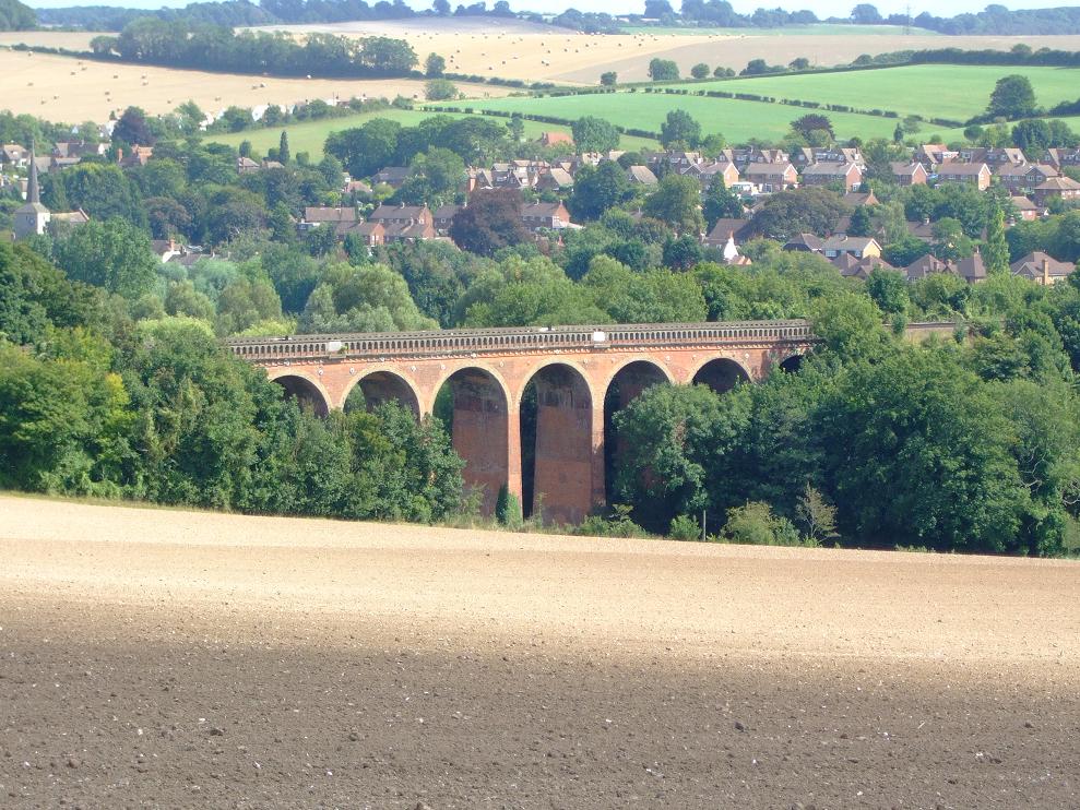
Anyway starting at Farningham Road station our nine man group, set off on this bank holiday Monday along the scenic Darenth Valley Path, following it upstream pretty much for the majority of the morning and afternoon. The day started a little bit chilly but the Sun eventually put in an appearance which meant I was soon able to take my rainjacket off. Initially we were just folllowing the river, but this soon expanded out into the valley itself.
.

Lunch was Eynsford where we had to cross over the footpath free bridge by the fjord, along with a large queue of motor cars, in order to reach the pub. Thus expanding my culinary repertoire I decided to try the fish and chips, and also had a Magners cider (much better than the gassy Strongbow). Anyway none of us had a pudding and we were soon back on the Darenth Valey Path again.

Now there was a Roman Villa in these parts that was being vaguely promised to me, as a stop off point. However that was in the grounds of the uninspiring Lullingstone Castle (hence no picture) so we didn’t get to see that. Instead after following the Darenth river we ended up, in a local tearoom where we were faced with an enormous queue, and a garden full of uncleared tables. I decided to have a Magnum Ice Cream (probably because I thought there was some sort of link with my earlier cider), and cleverly passed it back down the queue when I got near the till, for it to be replaced with another less melted one.

As we approached Shoreham station the group split into those who wanted to end there (which three of the group did), and those of us who were carrying on to Otford. In the course of which we passed by a golf course and cricket ground that we all had been past before on another walk. Anyway we eventually got to Otford station in time to watch the half hourly train pull out. Thus the next half hour was spent in a shelter debating the fate of a bee on the ground that had two cigarette butts beside it.

So overall a very scenic walk, in a nice Autumn temperature (I was comfortable in a t-shirt). In normal circumstances I might have grumbled that the pace was a tad too leisurely, however due to the severity of the run/walk I had done the previous day, that was probably all my legs could cope with.

Walks since last blog entry:
1 x 6.5 mile (run)/walk – Grand Union/Osterley Park

Sunday 22 August 2010

Chesham to Wendover – (Buckinghamshire) – 22/08/10 – 10.2 Miles – IVC


After the previous day’s National Trust gentle jaunt, it was back to some serious walking for this wander through the North of the Chilterns. Now most of us were confused in some way or other by the travel instructions, from Marylebone to Chesham. Not least me who for the third time now have paid the return train fare on this line, when my Oyster would have taken me all the way to Chesham. Thus I only really needed a single ticket back from Wendover to Amersham. Hopefully by the time I get to lead my Chequers walk, I will get it right and save some money. Another member getting it wrong was the guy who pulled his car up outside Chalfont & Latimer for the irregular branch line to Chesham, only to see us pull out and thus requiring him to come and chase us in his car.

All this served to wind up our leader who was fretting about missing the hourly train home, before the walk had even started, and which was to become a theme throughout. Thus given that he is one of the fastest walkers in IVC, this served only to encourage him to really push the pace, and for quite a few stretches I was the only one (when I had a mind to) who could catch him up and stay with him. That said I found it refreshing to be walking at a decent pace, and according to my (pinch of salt) GPS, when we were moving (as opposed to waiting for everyone to catch up) we averaged 3.5mph throughout the walk.

At one point whilst comparing general GPS readings with our (much slower) leader of all leaders, I popped mine back in my rucksack side pocket and walked on. By some miracle I decided I would get it out again to give it a second check, only to discover I had missed the pocket and thrown it some way back on the ground (thankfully its bright yellow casing called out to me to in the Sun to come and rescue it). Thus by this time the Sun had come out to give a much brighter day than Saturday, and one that was slightly less humid as well. Our nine strong group also found itself being joined at different points by two small dogs and further on by two larger ponies.

Lunch was at the Cock and Rabbit which seemed part pub and part Italian bistro. Thus the Don Corleone figure who took our orders at the bar left one in no doubt about the authenticity of the establishment, or the potential consequences if you didn’t pay your bill. The rather impressive young waitress also had an Italian name, so we are definately talking family here (if you know what I mean). Anyway given that my flat is full of ready meals coming near their sell by date (plus the fact that I had fish & chips in the pub yesterday, thus limiting my choices) I chose to slurp away on the vegetable soup and garlic bread (+ pint of Strongbow).

Post lunch and our leader went straight back into his fretting about the train mode. All of this was quite amusing given that on the one hand he felt we had to be at Wendover station for five o clock, but on the other hand didn’t actually know when the train actually left. Even more amusing was that soon afterwards he had taken us all on a wrong turn, confirmed by yours truly’s GPS (not that I was given any thanks for this assistance). Thus our leader then officially announced with some exasperation that we now had no chance of making the five o clock (?) train, an opinion he was continually to revise throughout the rest of the afternoon.
.

After walking through a number of beautiful sunbaked Weetabox fields, we eventually picked up the Ridgeway (parts of which I covered on the Coombe Hill/Chequers excursion). Running alongside it was basically a sheer drop into a valley below. The only problem being that our leader required us all to descend straight down it (paths not included). This however was too much for four of our group, who led by the slower leader of all leaders, decided they were taking a different route at this point. Wisely, given age and ability considerations, they decided risking missing the train, was better than risking breaking their necks. Anyway five of us did it, although it was certainly precarious not least for the bracken and wood one had to trip ones way through (believe me the picture does not do this descent justice). No sooner had we reached the bottom of this valley however, we were then required to make an immediate ascent back up the lions share of Boddington Hill. Yet even then the endurance test wasn’t over, as yet again we were required to make the steepest of descents again. This time yes, it was on a smooth wide path, however such was the drop you could barely stop yourself from breaking into a run down it.
.

Once all that aerobic activity had come to a finish we walked through the virtually closed town of Wendover, arriving at the station at 1645, leaving us plenty of time for the 1713 train to Marylebone. Thus according to my (pinch of salt) GPS, we had covered 10.2 miles which our leader seemed in broad agreement with. There was some worry whether the other four who had taken a different route would make the train, but despite adding another mile, they were all present and correct on the platform by 1705.

Saturday 21 August 2010

Knole House (out and back) – (Kent) – 21/08/10 – 4.5 Miles – IVC


A recent IVC Summer walking innovation, is to have an additional shorter walk on a Saturday, combined with a visit to a National Trust property. As this was the first Saturday I have had free since …….. (oh I dunno, the Normal invasion probably) then here was an opportunity to support this new idea. Thus today’s event was slated to be a six mile walk combined with a visit to Knole House in Kent.

Starting at Sevenoaks station our twelve strong group soon found its way into the property’s Deer Park, which apparently in its entirety is 1000 acres (although the Trust only owns 43 acres worth). After a mile and a half we reached the driveway to the house where a small breakaway group went straight in, with the rest of us continuing our walk in the grounds of Knole Park estate. All around us there were plenty of young deer to be seen, as well as a number of golfers. So much so in fact that there were warning signs regarding the golfers. Thus in a brilliant flash of wit, I pointed out to everyone that the signs were there as it obviously must be the putting season.

As we headed off in the direction of the pub, the sky looked very overcast and threatening, yet this was one of the most humid days I can ever remember (or either I have some sort of fever) as I was sweating buckets. Lunch was at the Bucks Head where three of us had the last of the fish and chips, plus I had a pint of strongbow. After retracing our steps back to the house, those of us with National Trust membership or visitor cards got in for nothing, whilst the rest of the party had to pay £10.50 each.

Knole House has been in the residence of the Sackville family since 1566, although the heart of the building was built substantially earlier between 1456 and 1486. Now a lot of what one sees here, tends to be familiar to a lot of National Trust properties. Although I did particularly enjoy the erotic carving at the foot of the stairs of a lady reclining on a couch, the portrait of James 1st (when a steward pointed out to me how his eyes and left foot follow you around), and also had my interest piqued by the fact that this was where The Beatles made the videos (or whatever they were called then) for both Strawberry Fields and Penny Lane. Also I have just now looked on Wikipedia where the it says the property is known as a calendar house because it is reputed to have 365 rooms, 52 staircases, 12 entrances and 7 courtyards. Needless to say nothing like that is on view to the public, as the Sackville-Wests still own half the house, all of the gardens, and the majority of the estate.

So after buying an eco stapler in the gift shop I reassembled with everyone else in the tea rooms, where I had a mug of coffee and a slice of coffee cake (well I like coffee !). The plan at this stage was to follow the same route home, however a shorter more direct route was devised of about a mile and a half, through the main entrance and back into Sevenoaks. So overall an interesting and relaxing day.

Walks since last blog entry: 1 x 9.25 mile (9 kg ruckack walk) – Putney to Osterley.

Thursday 5 August 2010

Chequers / Coombe Hill (Circulars) – (Buckinghamshire) – 05/08/10 – 10 Miles – Myself

An unexpected day off from work gave me a chance to make another attempt at the Chequers walk, which me and Helen ultimately gave up on back in June. My reasoning being that one head + GPS, is better than two heads and no GPS. Also I had vaguely promised on Sunday that I would lead a walk for IVC in September, with this looking the most likely candidate. So talking of the GPS, it was a pleasant surprise to see that the grid reference on the ‘route cut out from Country Walking (May 2010 issue) exactly corresponded with what the GPS was telling me (not sure why I expected it to be different – but anyway).

Obviously the first four and a bit miles of this one was not expected to present me with any problems, being that we had done it both ways last time out. The only difference this time was that I had spotted a potential early lunch stop for IVC the previous evening whilst studying the small map. Thus in no time I had reached the Boer War Monument on the top of Coombe Hill, which admittedly is only at the 1.5 mile point (or is it, as the GPS only showed 1.38 miles – more on that later). Also and thankfully the wild ponies were nowhere to be seen.

Now the pub lunch stop, involves leaving Coombe Hill (Monument), in the complete opposite direction to the route, and thus descend down to Butlers Cross. Oh my my though, what a steep and precarious descent. Yet when I finally got down to the road, the golfers crossing there pointed out that there wasn’t any footpath, and that I would have to walk on the road itself. However after about half a mile, I arrived at The Russell Arms, where I had a pint of cider, and two eggs, ham and chips. Everything was as it should be there, which was just as well considering at 12.30 I was their only customer. What goes down must come up though (relax I am not talking about lunch), and the ascent back up Coombe Hill (now the second ascent of this) was in a league of its own, and bore no relation to the gentle climb from the station. I like to attack a climb but this one had me stopping and panting hard every 20 yards. Eventually I made it back to the Monument where I temporarily collapsed in a heap to get my breath back. Methinks I better make this clear with IVC, and suggest the majority bring sandwiches.

Continuing on from the Monument this time I took the correct path (to last time out) all the while admiring the stunning views over the Vale of Aylesbury, then continued through the beech wood, before eventually and correctly doing a right turn (again unlike last time) out onto the road. There I picked up the Ridgeway/South Bucks Way through the wood before eventually leaving there and crossing the road that takes you into the grounds of Chequers estate. No idea whether Cameron was in residence, but there was a small number of workers with strimmers cutting green stuff (although in all likelihood they were probably Mi5 operatives carrying disguised machine guns). Not wishing to risk the wrath of anyone, I stayed on the correct path, eventually walking past the wood on my left, and railway sleepers to my immediate, and chequers to my far, right (if you check out the photo you can spot Coombe Monument in the distance).

So finally I had arrived at the bit that had caused us so much grief last time out. Having taken an immediate grid reference reading, it was apparent that not only was I not as far along as we thought we were at that time, but I still wasn’t as far along as we thought, when we assumed we had sussed it all out in the aftermath. Nevertheless this is still a confusing section, and I did resort to the inbuilt compass in the GPS here, to make sure I was heading in a general Northerly direction. The other big mistake we made back then was thinking that Great Kimble on our left was actually Beacon Hill. In fact we never got as far along on the last trip to see Beacon Hill, which was ultimately further along and on our right. The correct thing to do was to cross the road that I had traversed down to Chequers before (along with any number of other dead ends we had taken). Helen did suggest this, along with other suggestions as well, but at that time I was becoming overstressed and cooked by the heat and it was just one suggestion to many. So near and yet so far.
.

Today of course is a different day, and with the GPS to keep me on track I sailed past Beacon Hill on my right, with more stunning views over on my left. Eventually I reached the road, and took an immediate right down the lane opposite the church at Ellesborough. Cutting across a vast field of straw I could once again spotted the Coombe Monument way up in the distance. Once out onto the road it was past the golf club and left onto the bridleway to make ascent number three of Coombe Hill. Well this one was every bit as bad as the the second one from the pub at Butlers Cross (I can’t wait to see this string out a walking group), but eventually it levelled out and dissected the path from the Monument at the kissing gate, that I had come through earlier.

Carrying straight on I crossed a car park into Low Scrubs, with the ‘route cut out’ stating that the path is hard to follow. Well that would be because there are three paths, and naturally I took the wrong one. After 5 minutes I began to suspect this, and one grid reading soon confirmed it. It was then a case of retracing my steps and correctly picking the right path from the two remaining. Eventually I picked up a bridleway that went on for a good mile, firstly on a long descent and then taking a sharp left where I had to make way for both a mountain biker and then a girl on a horse. After crossing another green and glorious field, I found myself coming out onto the road bridge just outside Wendover station and thus ending the walk. So overall I was mighty pleased with my efforts as well as the walk which in its entirety is definitely one to do over and over again (what a shame me and Helen didn’t get to complete it back in June). That said the GPS was a vital tool today without which I would have still struggled at the point we did last time, and would most definitely have had problems at Low Scrubs.

However speaking of which, I was most perturbed when I got to the station to see the read out saying that I had only walked 8.89 miles. Well that can’t be right methinks, as it says 9 miles on the ‘route cut out’ and I had to have added at least a mile to that on the diversion and back to Butlers Cross for lunch. My guess therefore is that the GPS satellites measure distance in straight flat lines, and thus make no allowance for ascents (for instance a mile ascent up, may only be 400 metres covered in a straight line). Thus given that there were three ascents here, two of which being exceptionally severe, then that must be where my missing mile went. Anyway I will ask around on that one.
.
.
Walks since last blog entry:
1 x 6.5 mile (run)/walk – Grand Union/Osterley Park

Sunday 1 August 2010

Riddlesdown to Coulsdon South – (Croydon) – 01/08/10 – 8 Miles – IVC


My first walk with IVC for a couple of months and (even more important) my first chance to test out my new GPS (The Garmin E Trex H, for those of you who need a product reference). Therefore I think it is only fitting that I deal with that first. Thus the day started well as I was able to see the average speed of the train I was travelling on, how long it was waiting at the station, and how far it travelled between stops. Then once on the walk itself I was able to compare/check the map grid location with our walk leader’s OS map (everything working as it should there then), as well as compare general GPS owners chit chat with our leader of all leaders, who happens to have the exact same model. There was one annoying member of our group who felt he should be the centre of attention, merely because he had just completed a 100km walk along the South Downs in under 30 hours, however I did my best to drown him out with regular updates to everyone over how far we had just come. In fact everything was going swimmingly up until lunch, and then the batteries ran out …………. Oh dear, it looks like my old rechargeables that have hung about the flat for ever, may not be up to the job, and that I might have to invest in some real ones. So swiftly moving on…….

This walk was loosely based on a couple of stages of the London Loop, despite our leader’s reluctance to admit that (the signs however were a bit of a give away). Thus our first point of interest was RAF Kenley (circa 1940’s) situated on Kenley Common. Well actually I am inaccurately stating that, as these days it is used merely as an aerodrome for gliders (but watch the film The Battle of Britain, for a true reference point). Thus having left there in the course of which we were overtaken by a lady on her mobility scooter (+dog), we eventually made our way into Coulsdon Common, before ultimately arriving at our lunch stop at The Fox pub in Old Coulsdon.

Having arrived at the pub we were surprised to see one of the regular members already there tucking into his main course. It turned out he had missed the train, but by a combination of buses and cycle routes had made his way there via a different route to us. Now this was a really nice pub where the food was reasonably priced (for example £7.95 for a roast dinner), the service was quick and friendly, with the pretty young waitresse’s circling round us diners with an elaborate tray of sauces and mustards . For my purposes I had the open Chicken and Ham pie, with Fries and Peas, as well as the compulsory pint of Fosters. All very nice too, in fact so much so that I decided it was urgent that I had a desert to go with it. Now unlike the usual six quid a throw which seems to be most pub deserts these days, the Profiteroles (with fresh cream and chocolate fudge sauce) were a far more reasonably priced £3.95. Oh my god though you had to see the size of them to believe it, as in effect what I was served was to all extents and purpose two helpings. So as yummy as they both were, they actually beat me, and I was reduced to hiding the last couple of mouthfuls under my spoon.

The second half of the walk took us through the chalk ridges and dry valleys which form the dip slope to the North Downs. Undeterred with the fact that my GPS was now only able to stay on for a couple of seconds at a time, I tried to convince anyone who would listen (and there weren’t many takers at this point) that we had really only travelled 4.82 miles by the time we reached Coulsdon South station. Fortunately (lest anyone might have felt short changed) our leader of all leaders was able to pull out his fully powered one, and confirm that we had actually travelled 8.1 miles. Anyway the battery issue is merely a teething problem, with my new GPS looking as if it does everything I want it to do, and it will prove a good investment.
NOTE: The new photo size is an experiment for this post, based on the fact that most people probably don't click on the pictures themselves for a larger version. Anyway if it doesn't look right on this post I will return to the old format.