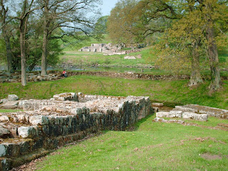
Undeterred we pushed on towards the roundabout, only to come across a 1km diversion off our route in order to see the Roman remains of Chesters Bridge that crossed the River North Tyne. Suitably impressed we walked back up to the roundabout and today’s bridge that crosses the river, only to stumble across a small café where we could replenish our stocks. So two Cokes, two bags of crisps, two Mars bars and an ice cream, all for just over three quid, either represents a good deal for the walking consumer, or the young girl serving hadn’t quite got the hang of the till (no idea what Helen paid for her sensible sandwich by the way).

We walked on, yet even whilst my ice cream was still a recent sticky memory, we had reached the entrance to Chesters Roman Fort and Museum. As is to be expected the English Heritage lackeys weren’t content to just sell us a ticket, but also wanted us to take out lifetime membership as well, but we politely took their leaflet instead and said we would think about it later. Inside the museum itself was a large number of stone engravings as well as the expected exhibits of pottery and coins. Outside however was the real deal, with the visible remains of the cavalry fort, with separate barracks, bathhouses, and commanding officers quarters. What was really exciting though, was when we realised (a bit slow you see) that we were now standing on the opposite side of the river to Chesters bridge that we were looking at earlier, and which was of course the link road to the fort.


Upon leaving the fort/museum however it suddenly struck me that it was now quarter to midday, and that in effect we had only covered 1 mile, with another 11 of the planned route still to do. Thus I spent the rest of the day acting as some sort of Roman Centurion eager to cover the open ground quickly, whilst Helen played the part of a rebellious slave girl determined to go at her own pace, stopping whenever tired or hungry. To be fair however it wasn’t just the rebellious slave girl, that was holding things up, as this was where the the whole thing started to really come together. Thus the more the gap widened between us and the B6318, the more turrets, milecastles, temples and sections of wall there was to stop and look at. We also started to be more aware of the North ditch (even in the absence of Wall), the South Vallum (another series of ditches designed to protect the troops from cattle rustlers and the like in their rear), and the near parallel Military Road. The view Northwards was also getting ever more impressive.
Despite a minor incident (that potentially could have wrecked the holiday) when a wasp conspired to get between my glasses and my eye, things were going well. That is until we came to a small farm in the Sewing Shields region. Here we found ourselves faced with a choice of about three different routes, at the one point of the whole path when the sign posts had mysteriously disappeared. Thus just as we were trying to concentrate we found ourselves assailed for several minutes by the smallest and noisest of dogs, who was determined to make all and sundry aware that there were walkers in the region, who may be cutting across the farmyard (fuelling my suspicions as to whether there orginally was a sign, which had been disposed of). Needless to say this wasted a fair chunk of time, with us having to ask three different people (on assorted Quad bike’s, Range Rover’s or Horse’s) before we eventually got back on track.
So although we were very close to Housesteads Fort, which was intended to be one of the walks major highlights, we were still three long climbing miles from our finish point. It was therefore decided that we could come back on the bus for that one the next day, or maybe the day after (in the event neither). Past Housesteads however, and past the link with the Pennine Way, the full frontier majesty of the wall and the sparse country it was defending really came into its own. Thus despite the fact that we were now tired, hungry, getting colder and facing one gradient after another, this particular stretch remains my own personal highlight of the whole 5 days. The photos here of the wall and yet another milecastle, cannot do it full awe inspiring justice.

After coming across a series of young unlikely walking sorts (one carrying a guitar) we guessed our finish point at Steel Rigg car park must be nearby. Thus we were grateful when our B&B host came and picked us up from there, rather than let us walk an extra unwanted mile. That is what I call service, although I suspect it was hidden somewhere in the evening’s dinner bill the following morning.

No comments:
Post a Comment